1. Features
‧ Builds Skytraq Venus 6 high performance and low power consumption GPS Chipset.
‧ 65 parallel satellite-tracking channels for fast acquisition and reacquisition.
‧ Built in high gain LNA.
‧ Extremely fast Time-To-First-Fix(TTFF) at low signal level.
‧ Support NMEA 0183 v3.01 data protocol.
‧ For Car Navigation,Marine Navigation,Fleet Management,AVL and Location-Based Services,Auto Pilot,Personal Navigation or touring devices,Tracking devices/systems and mapping devices application.
2. Technical Specifications
(1) Receiver Type
‧ L1 frequency
‧ GPS C/A code
‧ 65-channel architecture
(2) Sensitivity
‧ -160dBm Acquisition
‧ -165dBm tracking
(3) Open sky Acquisition time
‧ 38 second cold start TTFF
‧ 1 second hot start
(4) Position accuracy
‧ Position 5m CEP without SA
‧ Velocity 0.1m/sec
‧ Timing 60ns
(5) Operational Limits
‧ Altitude <18,000meters (60,000 feet )
‧ Velocity < 515m/s
‧ Acceleration: 4 G, max
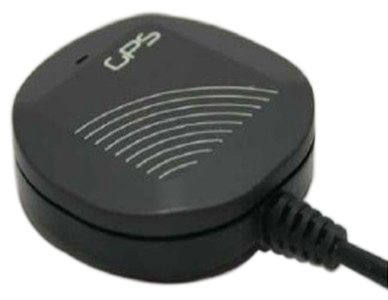
(6) Physical Characteristics
‧ Dimension: 53 * 53 * 15 mm
(7) Environmental Characteristics
‧ Operating temperature:
-40�� to + 85��
‧ Storage temperature:
-45�� to +100��
‧ Operating humidity:
5% to 90% No condensing.
‧ Power consumption
< 70mW at 3.0 - 5.5V input
(8) Protocol
‧ Datum: Default WGS-84
‧ NMEA output protocol: V.3.01
‧ Baud rate: 9600 bps
‧ Update Rate: 1 Hz
‧ Format: default GGA, GSA, GSV, RMC, VTG
3. Physical Dimension
|
IO Interface
|
Voltage level
|
|
4 pin 2.5/3.5mmEarphone Jack
|
UART(TTL level)
|
|
CN1 Pin
|
Pin define
|
Level
|
|
1
|
VCC
|
3.0—5V Dc
|
|
2
|
RXD
|
TTL input/ RS232
|
|
3
|
TXD
|
TTL output/ RS232
|
|
4
|
GND
|
Ground
|
|
Pin
|
Description
|
Internal wire color
|
|
1
|
NC
|
|
|
2
|
GND
|
Ground
|
|
3
|
RXD
|
TTL input/ RS232
|
|
4
|
TXD
|
TTL output/ RS232
|
|
5
|
VDD
|
3.0—5V Dc
|
|
6
|
NC
|
|
|
Pin
|
Pin define
|
Level
|
|
1
|
VCC
|
3.0—5V Dc
|
|
2
|
TXD
|
TTL input/ RS232
|
|
3
|
RXD
|
TTL output/ RS232
|
|
4
|
GND
|
Ground
|
|
5
|
GND
|
Ground
|
4. Software Interface
The output data in NMEA-0183 format as defined by the National Marine Electronics Association (NMEA), Version 3.01 Standard.
The default communication parameters for NMEA output are 9600 baud, 8 data bits, stop bit, and no parity.
Table 4-1 NMEA-0183 Output Messages
|
NMEA Record
|
Description
|
|
GPGGA
|
Global positioning system fixed data
|
|
GPGLL
|
Geographic position- latitude/longitude
|
|
GPGSA
|
GNSS DOP and active satellites
|
|
GPGSV
|
GNSS satellites in view
|
|
GPRMC
|
Recommended minimum specific GNSS data
|
|
GPVTG
|
Course over ground and ground speed
|
NMEA Message
The full descriptions of supported NMEA messages are provided at the following paragraphs.
GGA - Global Positioning System Fix Data
Time, position and fix related data for a GPS receiver.
Structure:
$GPGGA,hhmmss.sss,ddmm.mmmmm,a,dddmm.mmmmm,a,x,xx,x.x,x.xx,M,x.xx,M,,xxxx*hh<CR><LF>
1 2 3 4 5 6 7 8 9 10 11 12
Example:
$GPGGA,212742.954,2448.13492,N,12058.16712,E,1,09,1.0,19.31,M,19.40,M,,0000*60<CR><LF>
|
Field
|
Name
|
Example
|
Description
|
|
1
|
UTC Time
|
212742.954
|
UTC of position in hhmmss.sss format, (000000.000 ~ 235959.999)
|
|
2
|
Latitude
|
2448.13492
|
Latitude in ddmm.mmmmm format
Leading zeros transmitted
|
|
3
|
N/S Indicator
|
N
|
Latitude hemisphere indicator, ‘N’ = North, ‘S’ = South
|
|
4
|
Longitude
|
12058.16712
|
Longitude in dddmm.mmmmm format
Leading zeros transmitted
|
|
5
|
E/W Indicator
|
E
|
Longitude hemisphere indicator, 'E' = East, 'W' = West
|
|
6
|
GPS quality indicator
|
1
|
GPS quality indicator
0: position fix unavailable
1: valid position fix, SPS mode
2: valid position fix, differential GPS mode
3: GPS PPS Mode, fix valid
4: Real Time Kinematic. System used in RTK mode with fixed
integers
5: Float RTK. Satellite system used in RTK mode. Floating integers
6: Estimated (dead reckoning) Mode
7: Manual Input Mode
8: Simulator Mode
|
|
7
|
Satellites Used
|
09
|
Number of satellites in use, (00 ~ 12)
|
|
8
|
HDOP
|
1.0
|
Horizontal dilution of precision, (00.0 ~ 99.9)
|
|
9
|
Altitude
|
19.31
|
mean sea level (geoid), (-9999.99 ~ 17999.99)
|
|
10
|
Geodal Separation
|
19.40
|
Geoidal separation (-9999.99 ~ 17999.99)
|
|
11
|
DGPS Station ID
|
0000
|
Differential reference station ID, 0000 ~ 1023
NULL when DGPS not used
|
|
12
|
Checksum
|
60
|
|
GLL – Latitude/Longitude
Latitude and longitude of current position, time, and status.
Structure:
$GPGLL,ddmm.mmmmm,a,dddmm.mmmmm,a,hhmmss.sss,A,a*hh<CR><LF>
1 2 3 4 5 6 7 8
Example:
$GPGLL,2447.96928,N,12059.63137,E,211903.945,A,A*5F<CR><LF>
|
Field
|
Name
|
Example
|
Description
|
|
1
|
Latitude
|
2447.96928
|
Latitude in ddmm.mmmmm format
Leading zeros transmitted
|
|
2
|
N/S Indicator
|
N
|
Latitude hemisphere indicator
‘N’ = North
‘S’ = South
|
|
3
|
Longitude
|
12059.63137
|
Longitude in dddmm.mmmmm format
Leading zeros transmitted
|
|
4
|
E/W Indicator
|
E
|
Longitude hemisphere indicator
'E' = East
'W' = West
|
|
5
|
UTC Time
|
211903.945
|
UTC time in hhmmss.sss format (000000.000 ~ 235959.999)
|
|
6
|
Status
|
A
|
Status, ‘A’ = Data valid, ‘V’ = Data not valid
|
|
7
|
Mode
Indicator
|
A
|
Mode indicator
‘N’ = Data not valid
‘A’ = Autonomous mode
‘D’ = Differential mode
‘E’ = Estimated (dead reckoning) mode
‘M’ = Manual input mode
‘S’ = Simulator mode
8 Checksum 09 Number of satellites in use, (00 ~ 12)
|
|
8
|
Checksum
|
09
|
Number of satellites in use, (00 ~ 12)
|
GSA – GNSS DOP and Active Satellites
GPS receiver operating mode, satellites used in the navigation solution reported by the GGA or GNS sentence and DOP values.
Structure:
$GPGSA,A,x,xx,xx,xx,xx,xx,xx,xx,xx,xx,xx,xx,xx,x.x,x.x,x.x*hh<CR><LF>
1 2 3 3 3 3 3 3 3 3 3 3 3 3 4 5 6 7
Example:
$GPGSA,A,3,05,12,21,22,30,09,18,06,14,01,31,,1.2,0.8,0.9*36<CR><LF>
|
Field
|
Name
|
Example
|
Description
|
|
1
|
Mode
|
A
|
Mode
‘M’ = Manual, forced to operate in 2D or 3D mode
‘A’ = Automatic, allowed to automatically switch 2D/3D
|
|
2
|
Mode
|
3
|
Fix type
1 = Fix not available
2 = 2D
3 = 3D
|
|
3
|
Satellite used 1~12
|
05,12,21,22,30,09,18,06,14,01,31,,
|
Satellite ID number, 01 to 32, of satellite used in solution,
up to 12 transmitted
|
|
4
|
PDOP
|
1.2
|
Satellite ID number, 01 to 32, of satellite used in solution,
up to 12 transmitted
|
|
5
|
HDOP
|
0.8
|
Horizontal dilution of precision (00.0 to 99.9)
|
|
6
|
VDOP
|
0.9
|
Vertical dilution of precision (00.0 to 99.9)
|
|
7
|
Checksum
|
36
|
|
GSV – GNSS Satellites in View
Number of satellites (SV) in view, satellite ID numbers, elevation, azimuth, and SNR value. Four satellites maximum per transmission.
Structure:
$GPGSV,x,x,xx,xx,xx,xxx,xx,…,xx,xx,xxx,xx *hh<CR><LF>
1 2 3 4 5 6 7 4 5 6 7 8
Example:
$GPGSV,3,1,12,05,54,069,45,12,44,061,44,21,07,184,46,22,78,289,47*72<CR><LF>
$GPGSV,3,2,12,30,65,118,45,09,12,047,37,18,62,157,47,06,08,144,45*7C<CR><LF>
$GPGSV,3,3,12,14,39,330,42,01,06,299,38,31,30,256,44,32,36,320,47*7B<CR><LF>
|
Field
|
Name
|
Example
|
Description
|
|
1
|
Number of message
|
3
|
Total number of GSV messages to be transmitted (1-3)
|
|
2
|
Sequence number
|
1
|
transmitted (1-3)
|
|
3
|
Satellites in view
|
12
|
Total number of satellites in view (00 ~ 12)
|
|
4
|
Satellite ID
|
05
|
Satellite ID number, GPS: 01 ~ 32, SBAS: 33 ~ 64 (33=PRN120)
|
|
5
|
Elevation
|
54
|
Satellite elevation in degrees, (00 ~ 90)
|
|
6
|
Azimuth
|
069
|
Satellite azimuth angle in degrees, (000 ~ 359 )
|
|
7
|
SNR
|
45
|
C/No in dB (00 ~ 99), Null when not tracking
|
|
8
|
Checksum
|
72
|
|
RMC – Recommended Minimum Specific GNSS Data
Time, date, position, course and speed data provided by a GNSS navigation receiver.
Structure:
$GPRMC,hhmmss.sss,A,dddmm.mmmmm,a,dddmm.mmmmm,a,x.xx,x.xx,ddmmyy,,,a*hh<CR><LF>
1 2 3 4 5 6 7 8 9 10 11
Example:
$GPRMC,211904.745,A,2447.96772,N,12059.63052,E,0008.04,203.92,170726,,,A*51<CR><LF>
|
Field
|
Name
|
Example
|
Description
|
|
1
|
UTC Time
|
212742.954
|
UTC time in hhmmss.sss format (000000.000 ~
235959.999)
|
|
2
|
Status
|
A
|
Status
‘V’ = Navigation receiver warning
‘A’ = Data Valid
|
|
3
|
Latitude
|
2447.96772
|
Latitude in dddmm.mmmmm format
Leading zeros transmitted
|
|
4
|
N/S indicator
|
N
|
Latitude hemisphere indicator
‘N’ = North
‘S’ = South
|
|
5
|
Longitude
|
12059.63052
|
Longitude in dddmm.mmmmm format
Leading zeros transmitted
|
|
6
|
E/W Indicator
|
E
|
Longitude hemisphere indicator
'E' = East
'W' = West
|
|
7
|
Speed over ground
|
0008.04
|
Speed over ground in knots (0000.00 ~ 0971.92)
|
|
8
|
Course over ground
|
203.92
|
Course over ground in degrees (000.00 ~ 359.99)
|
|
9
|
UTC Date
|
170726
|
UTC date of position fix, ddmmyy format
|
|
10
|
Mode indicator
|
A
|
Mode indicator
‘N’ = Data not valid
‘A’ = Autonomous mode
‘D’ = Differential mode
‘E’ = Estimated (dead reckoning) mode
‘M’ = Manual input mode
‘S’ = Simulator mode
|
|
11
|
Checksum
|
51
|
|
VTG – Course Over Ground and Ground Speed
The Actual course and speed relative to the ground.
Structure:
GPVTG,x.xx,T,,M,x.xx,N,x.xx,K,a*hh<CR><LF>
1 2 3 4 5
Example:
$GPVTG,317.20,T,,M,0017.68,N,00032.75,K,A*01<CR><LF>
|
Field
|
Name
|
Example
|
Description
|
|
1
|
Course
|
317.20
|
True course over ground in degrees (000.00 ~ 359.99)
|
|
2
|
Speed
|
0017.68
|
Speed over ground in knots (0000.00 ~ 0971.92)
|
|
3
|
Speed
|
00032.75
|
Speed over ground in kilometers per hour (00000.00 ~
01800.00)
|